DH Press Beta Pilot Projects

We are working on four beta pilot projects to field test DH Press. Using Robert Allen’s AMST 840: Digital Humanities/Digital American Studies graduate seminar as the test bed, we have devised four unique projects in collaboration with various “clients” (or partners) across the university, the state, and the globe. The ten or so graduate students working in teams with these clients represent a range of disciplines: Information/Library Science, Education, Geography, Religious Studies, and History. These projects will launch by the beginning of May, though some of them will be proof of concepts, and others will be part of larger projects that the DIL will continue working on after the end of the semester.

Field-Based Learning Project

Field-Based Learning Project

This project explores the potential uses of digital tools in two Honors Study Abroad and Burch Field Research Seminars: Chris Teuton’s Burch Field Research Seminar: Cherokee History, Language, and Culture (postponed) and Lucia Binotti’s Honors Program in Rome (Summer 2013). Building on a growing body of research focused on immersive learning environments, often through games and avatar simulations, this project will visualize the learning process for “in the field” contexts. The DH Press project will extend and enrich the learning environment, connecting the physical places the students encounter with the digital spaces of the DH Press course site.

Students in Rome will design thematic tours of the city based on a series of social, political and cultural responses to the intellectual trends that for almost three hundred years were at the heart of major developments in literature, the arts, the sciences, religion, and government, an encompassing historical phenomenon commonly known as The Renaissance. Students will build virtual tours as companions to the foot tours they will lead, and peers will be able to upload their own photos of the journey along the way.

The DH Press site for the Burch Field Research Seminar: Cherokee History, Language, and Culture is being designed as a way for students to situate their work in space, both virtual and physical. Whether it’s doing field work in Cherokee, N.C., traveling along the Trail of Tears, or working with members of the Cherokee Nation to learn Cherokee language and history, the work will be geolocated to help ground students in time and space.

The DH Press site for the Honors Program in Rome will be tested this summer, and if we can pass the ITS security audit in time, will be managed in the web.unc.edu WordPress environment.

Elissa Sampson (Geography doctoral student) and Susan Ivey (SILS masters student) are working on this project.

Global Theatre Mapping Project

“The Global Theatre Histories project investigates the emergence of theatre as a global phenomenon against the background of imperial expansion and modernization in the late 19th and 20th centuries.” For this project, three of our students are teaming up with a research group based at the Ludwig Maximilian University of Munich to develop a proof of concept for how to use DH Press to map the spread of western-style, purpose-built theatres across the globe from roughly 1860-1990.

Using an existing data set provided by the Munich research team, our students are exploring ways of extending the data to include additional attributes for visualization purposes, as well as investigate ways of mapping the movement of troupes and impresarios between and among these theaters.

Aron Sandell (Geography doctoral student, Kait Dorsky (SILS masters student), and Garrison Libby (SILS masters student) are working on this project.

Lebanese Migration to NC Project

Though largely unstudied, North Carolina has been a site of Lebanese migration throughout the twentieth century. From roughly 1890-1920 a first wave of Lebanese—nearly all Christians from Mount Lebanon in the Syrian Arab Republic—made their way to France and then to the northeast United States before traveling the railroads southward to North Carolina. By one count, there were 1,001 Lebanese living in N.C. in 1921. The presence of Lebanese in N.C., like other ethnic groups, complicates our understanding of race in the Jim Crow south. In a bi-racial social and legal system, where did Lebanese—legally deemed white in Dow v. United States (1915)—fit in N.C.? Where did they live and work? How were they treated?

The Khayrallah Program for Lebanese-American Studies at North Carolina State University inaugurated the Lebanese in North Carolina project in 2010 to research, preserve and publicize the history of the Lebanese-American community in North Carolina and the South from its earliest days in the 1890s through today. The project includes an online archive, and is preparing for a February 2014 exhibit at the NC Museum of History.

This is our third time teaming up with Akram Khater, History Professor at NCSU and director of the Lebanese in NC project, to trace and map Lebanese migration to NC in the first part of the twentieth century. This project uses census and city directory data, along with newspaper clippings and other archival material from the Lebanese in NC archive, to document migration patterns in Wilmington, Goldsboro, and Winston-Salem between 1900-1920. Our digital mapping project will be included in the 2014 museum exhibit.

Jacob Hill (SILS doctoral student), Mandy Bean (doctoral student in the School of Education), and Mishio Yamanaka (History doctoral student) are working with Akram’s team and our DIL undergraduate staff on this project.

Wilmington Race Riot Digital History Project

Wilmington, NC (the largest city in the state through the beginning of the twentieth century) suffered fierce power struggles between white elites and African-American Republicans during the period of Reconstruction (ca. 1865-1877) and well beyond, culminating in the Wilmington Race Riot of 1898. Inspired by a statewide white supremacy campaign, led largely by white Democrats and newspapers in Wilmington and Raleigh, the riot (or insurrection, or coup d’état) was fueled by biting political cartoons and editorials denouncing black rule, and targeted successful African American leaders and businessmen, including the only black-run newspaper in the state, The Daily Record. On 10 November 1898, an angry white mob set fire to the offices of The Daily Record, and the violence began to spread to the black community, leading elected black officials to resign by the end of the day. In the end, an unknown number of blacks were killed or driven from Wilmington in a “banishment” campaign, and the white elite returned to power.

The Wilmington Race Riot Digital History Project will create an interactive online version of the Wilmington Race Riot Commission’s Final Report (31 May 2006). The site, to be designed primarily for a K-12 audience, will form the basis for an eighth-grade social studies curriculum about the race riot, to be designed by the client, Christie Norris of the NC Civic Education Consortium. The challenge for this project is to balance the available rich data and vast archival materials with the ability to use DH Press to tell a story, particularly geared towards eighth graders. And given the sensitive nature of much of the content, an additional challenge will be finding a way to present that story and supporting materials in a clear manner that is appropriate to the primary audience.

Shannon Harvey (doctoral student in Religious Studies) and Pavithra Vasudevan (Geography doctoral student) are working on this.


Look for the launch of these projects by May 6!

A Closer Look at Maps in DH Press

In an earlier post, I mentioned that Chien-Yi has been adding a lot of functionality to the mapping piece of DH Press. Again, while the tool (we hope) is evolving well beyond just a geo-spatial visualization tool, we nonetheless want a robust mapping component to the plugin.

Map Library

First and foremost, DH Press will feature an extensible Map Library. Any map in your Map Library can be used in a project (just like items in your WordPress media library).

Chien-Yi has already loaded in all georeferenced maps served out by the Carolina Digital Library and Archives. If you need, say, the 1913 Sanborn map of Durham, all you have to do is search for it and select it. But if you need a map not already in the Library, we hope it will be easy to add. DH Press can currently support a range of base maps, CDLA maps of NC, KML maps, and other OpenLayers maps (although some API customization may be required to import other map libraries).

Base Layers

Whether your project requires a (historic) overlay or not, every map will have some sort of base layer when rendered to end users. Typical base layers include a range of Google Maps (street, satellite, hybrid) and OpenStreetMaps. We’ve also talked about adding in Bing Maps. Admin users will be able to set the base map layer, but can also allow end users to change the base layer (if more than one base layer is assigned to a project).

It will also be possible to upload your own customized KML base layer. That is, if you’ve created a map of your own using ArcMap, for example a set of polygons related to different neighborhoods in a city, you can upload it into the tool and use the KML, with all of its associated data, as the base layer. The KML will need to be served out from somewhere, though we think it will be possible to load it in as a media file into DH Press and serve it out locally.

Overlays

If your project requires it, you can also layer one or many maps over your base map. Currently, two main map types are supported: KMLs (again, these must be served out from somewhere) or CDLA Maps. But of course, we’re hoping to keep extending this map set, using map APIs whenever possible. Once we set this up, it should be fairly easy to add a new map overlay to your Map Library. By pasting in a URL and adding some accompanying metadata, you should be able to create new maps and add them to your projects. Because we’re using the OpenLayers protocol, pulling in OpenLayers maps should be fairly straightforward for us. We’re also exploring what it would take to pull in other geodata, such as datasets from PostGres/PostGIS, or Web Mapping Services (WMS) streaming geodata.

Map Legends

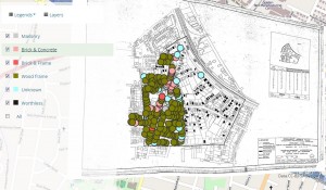
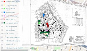
After you’ve added your maps to the Map Library and associated a particular map(s) with your project, you’ll be able to create as many map legends as possible, where you can specify your marker types, and assign filter fields. So, depending on what map view you’re in, you could see markers differentiated by different values associated with different attributes. For instance, here are two views of the same set of markers, one filtered by building type, the other by property owner. The different map legends allow you to visualize different attributes of your data.

1961 map of the Hayti community filtered on building type.

1961 map of the Hayti community filtered on property owner.


We’ll continue adding even more map functionality after the Beta 1.0 release, so stay tuned!

DH Press Sandbox

Recently, we set up a Sandbox for people who want to play with DH Press. It’s a multisite installation of WordPress, so no matter how many unique sites we set up, each site will be updated simultaneously whenever we update the DH Press plugin.

Currently, our AMST 840 students are the only ones playing in the Sandbox, largely because the plugin is not yet finished and because we don’t have enough documentation for users to play without guidance from the dev team. The ten or so graduate students enrolled in Robert Allen’s AMST 840: Digital Humanities/Digital American Studies are working in teams on client projects that will launch by the end of the semester (I’ll be blogging about those projects soon). Right now, we are training them to use DH Press in the Sandbox as they plan and gather data for their DH projects. It’s a challenge training users on a tool that is not yet complete, but our students have an adventurous spirit and a lot of patience with me and the rest of the team. As with any development process, things don’t always work as anticipated, and we figure out ways to break the tool each week (all towards the end of making it more and more robust)!

Once the beta plugin is done and we’ve got enough documentation under our belt, we’ll open up the Sandbox to anyone who wants to play. We can create a website for each sandbox user, and will provide some sample data to work on. Of course, if you have your own WordPress installation (not one hosted on wordpress.com because those sites don’t support plugins), you’ll be welcome to grab the plugin file, either from GitHub or from dhpress.org, and install it yourself. If you do this, you’d be able to fiddle with the code as much as you like!

DH Press Beta 1.0 Update

The DH Press development team has been hard at work since our recent rebrand. We had hoped to release the initial beta version of the plugin around Valentine’s Day, but we decided to alter course to incorporate additional functionality. We hope the release will now take place sometime in April.


Added Functionality

Maps

For starters, Chien-Yi has been working hard to bring robust mapping capabilities online. While we want to think of DH Press as something more than a geo-spatial data visualization and presentation tool, we certainly couldn’t release Beta 1.0 without the capability to load and markup maps. We currently have the ability to customize base maps (the maps underlying our data layers), and can pull in a few types of map overlays (including KMLs and CDLA historic maps). We’re working now to expand these possibilities for the first plugin release. I’ll be posting more details about our progress with maps shortly.

Foreign Key Relationships

While WordPress runs on a MySQL relational database (RDB), WordPress somewhat obscures the traditional structure of a RDB. That is, we don’t normally see the individual entities (tables) or attributes (data fields). As we originally envisioned it, after datasets are uploaded into DH Press via CSV Import, they can be structured and customized. For instance, you can create parent-child relationships between custom fields (attributes in a traditional RDB). This approach makes it easy for users who don’t know much about databases to create and work with their data. But for users who are experienced with RDBs, this approach can feel a bit limiting at times. So we plan to add a little more relational power.

Put simply, users will be able to load separate csv files (where each file corresponds to a particular entity, or table). Each csv file will have a custom field for primary keys (a unique identifier for a given piece of data) and another for the foreign keys (relationships to existing PKs; creates joins across entities). Once all files have been loaded into DH Press, admin users will have the ability to define their PKs and FKs to create links between their various data points, in much the way that a more traditional RDB works.

The beauty of this, of course, is that uses will not be required to create their data in this structured way for DH Press to work. Put another way, flat data files can still be imported and manipulated in DH Press, so the data creation piece remains straightforward for non-technical users. But this added functionality affords us the flexibility to accommodate both non-technical and technical admin users. This will all be explained in the admin user documentation about data creation.

Added Page Customization

Right now, we’re focusing much of our energy on improving customization options for admin users, not just to enable them to structure their data but also to generate interesting and engaging views and page layouts for site visitors. This is less about visual entry points (maps, timelines, network graphs), and more about customizing the type of content that will appear on the page for a given data point. Each data point is imported as a customized WordPress post. Every data point—whether a marker, an event on a timeline, or a network node—has a unique URL.

We envision providing a menu of choices for admin users to turn different content on/off for a given page, display or hide custom fields, and determine where fields appear on the page in relation to the rest of the content (e.g. the post content). Ideally, we’ll offer easy drag and drop layout design, and possibly some suggested templates (similar to Omeka’s Exhibit Builder), but we’re not yet sure how much of this customization will be included in the initial Beta release.

Documentation

Finally, Jade and I are beginning to work on admin user documentation. We have been delayed in this process until the plugin was stable enough to document. That is, we didn’t want to create documentation that could quickly become outdated as new functionalities were added to the tool. But now that we’re close to Beta release, we’ll begin creating short, modular videos and documents to walk users through the process of creating a project in DH Press. We plan to create the documentation in the same order as the project creation workflow (create a project in the tool > format your data > import it > structure and customize it, and so forth). We’ll be testing the documentation as we go along, but always welcome feedback.


Look for more details about map functionality, our new DH Press Sandbox, and the four beta projects we’re working on. And, as always, stay tuned for news of the release of DH Press Beta 1.0 and the launch of Mapping the Long Women’s Movement.

Rebranding diPH

In my last project update, I mentioned that we were rethinking the name “diPH” on the eve of the beta 1.0 release of our digital humanities toolkit. After some helpful feedback and many internal discussions about what the name of the toolkit ought to invoke, we’ve come up with “DH Press.” This plays off of the WordPress brand, similar to other tools out there like BuddyPress and CommentPress. On top of that, we hope that DH Press is suggestive of the ease with which you can create digital projects using our toolkit – just a “press” of the button and you’re on your way to publishing an online digital humanities project! Jade is working on some different logo concepts that will help us visualize and communicate the tool’s purpose and ease of use.

We’ll continue developing this concept as we gear up for our big launch. Look for that announcement … coming very soon.