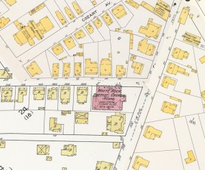
Graduate and undergraduate students in Lab-linked courses this fall will work together with Preservation Durham to develop a new Main Street, Carolina online resource documenting the history of the Hayti neighborhood of Durham, N.C. A team of graduate students from Robert Allen’s digital humanities/digital history seminar will design the project using the Main Street, Carolina software platform, working with our client/partner Andy Edmonds, a Preservation Durham board member. Using city directories and census enumerations, they will create a searchable database of Hayti residents and businesses in 1920, which can be displayed on the 1913 Sanborn Fire Insurance Maps of Durham. The graduate students will then work with a team of undergraduates taking Allen’s “Main Street, Carolina” course this fall (AMST 350), to develop crowd-sourcing techniques for data entry and metadata processing.
This project is being developed for Preservation Durham as a proof-of-concept model for a much more ambitious project to produce a comprehensive built-environment genealogy of Hayti, documenting the neighborhood’s development in the late 19th century, its heyday as the heart of the African-American community in Durham in the early 20th century, the “redlining” of the neighborhood in the late 1930s, and its eventual destruction as a result of “urban renewal” in the late 1960s. A Main Street, Carolina project undertaken by graduate students in fall 2010 (“Dividing Durham”) digitized and published the “redlining” map and accompanying documentation for Durham, making these key documents available to the public for the first time since their production in 1937.
The project will draw upon the complete set of digitized, “stitched,” and georeferenced Sanborn Maps for Durham published between 1884 and 1913 (7 separate map sets), which reveal the growth of Hayti and Durham as a whole at the level of the individual dwelling and commercial building.
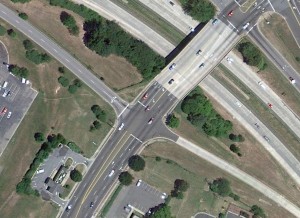
For this project, the maps will be “repurposed” from their use in “Going to the Show,” the award-winning digital history resource developed in collaboration with UNC Library’s Carolina Digital Library and Archive and Documenting the American South. As layers on top of contemporary satellite and street maps of Durham, the historical maps can be removed to reveal the built environment of what used to be Hayti as it is today.


